English → Upper secondary → Final two years & specialist English

Mapping England, 1066-1688: Territory and Memory

From the Bayeux Tapestry to the Bill of Rights: how maps make, claim and remember a territory.

C1+Programme axis: Territoire et mémoireProgramme axis: Art et pouvoirSpecialist English theme: Arts et débats d'idées8 stages + final project
Introduction → 1066 → 1688

Who draws the map owns the story

Welcome to the courseWho draws the map owns the story

Welcome to « Mapping England, 1066–1688: Territory and Memory ». This course takes you on a journey through six centuries of English history, from the Norman Conquest to the Glorious Revolution, and asks one powerful question: who draws the map, and why? In each stage, you will explore an original historical map or source, from the Bayeux Tapestry and the Domesday Book to the maps of Christopher Saxton and John Speed. You will observe, interpret and debate how maps were used to claim land, display power and shape a nation's memory. Real quotes, rich vocabulary and sentence starters will help you speak and write with confidence at C1 level. At the end, you will create your own memory atlas of England with your group and present it in a guided tour. History is not only about what happened; it is about how we choose to remember it. Let's start mapping!

Hook

When you open a map on your phone, who decided which places are shown, which are named, and which stay invisible?

Read: the text

A map looks innocent. It seems to describe a territory exactly as it is, with its coasts, rivers, roads and towns. Yet every map is an argument. Someone chose what to show and what to leave out, which names to write in large letters, what to put at the centre and what to push to the margins. Someone paid for it, and someone was meant to look at it. To map a place is to know it; to know it is, very often, to govern it.

Between 1066 and 1688, England was conquered, counted, taxed, divided by civil wars and rebuilt again and again. Across those six centuries, the people who ruled it kept producing images of the land: an embroidered strip of linen celebrating a conquest, a survey so thorough that the English compared it to the Last Judgement, monks' maps drawn along pilgrims' routes, county atlases decorated with royal coats of arms, battle plans sketched for generals and road maps designed for coaches. Each of these documents claimed the territory in a particular way, and each still shapes how the nation remembers its own past.

This course follows that story in eight stages. In each one, you will read an original text, study a primary source, work on a historical map or map-like document and debate one central idea: maps are never just about space. They are about power (who controls the land?), memory (which events are inscribed on it?) and identity (who belongs to it?). By the end, you will design your own memory map of England and defend the choices behind it.

Map lab: John Speed's Great Britain, 1611
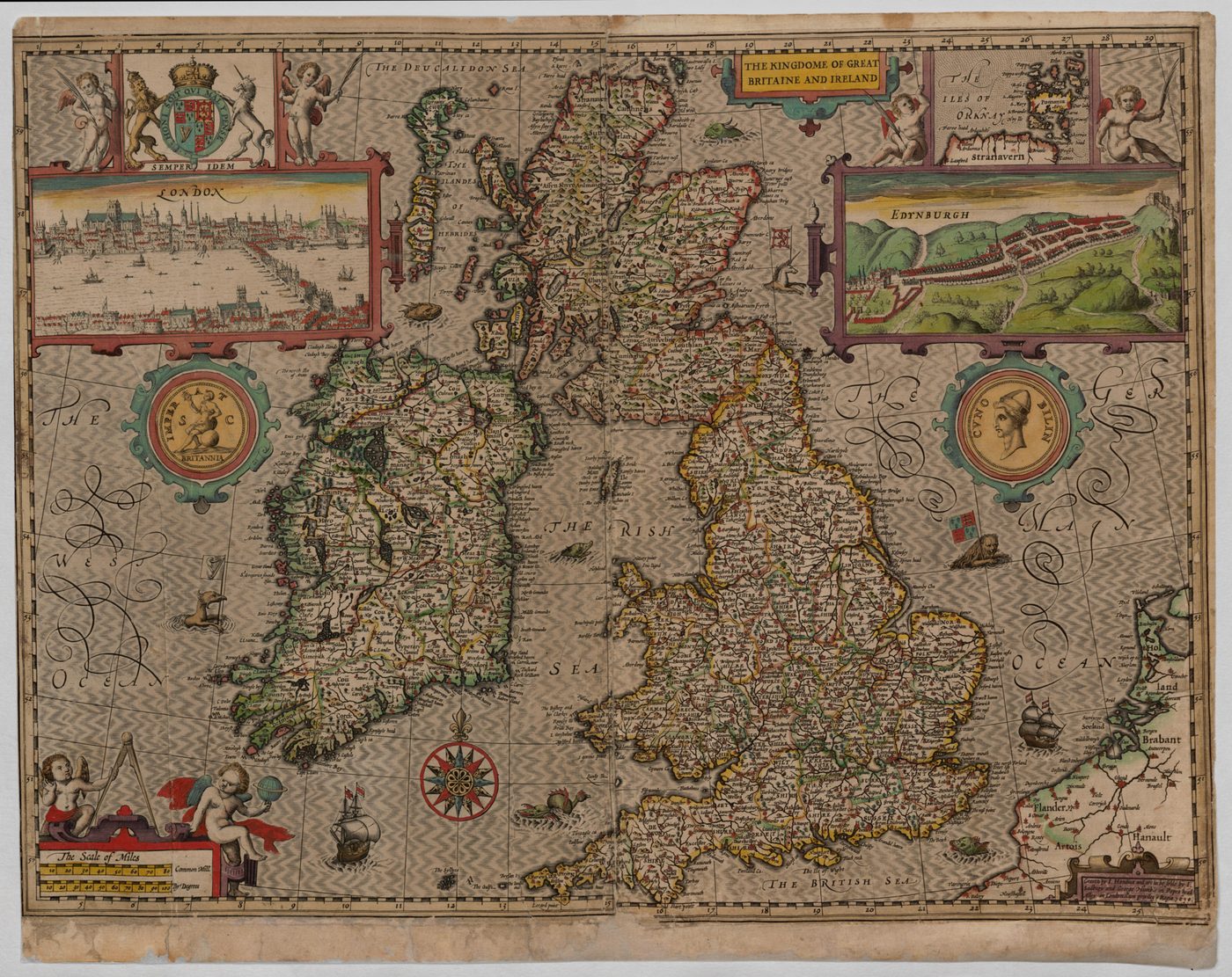
John Speed, The Kingdome of Great Britaine and Ireland (1611), engraved by Jodocus Hondius, from The Theatre of the Empire of Great Britaine.
John Speed, The Kingdome of Great Britaine and Ireland (1611), engraved by Jodocus Hondius, from The Theatre of the Empire of Great Britaine.Source: Cambridge University Digital Library, via Wikimedia Commons → Licence: Public domain → file page
  1. Observe → List three things the map shows besides coastlines (decorations, figures, inset images, writing).
  2. Interpret → James VI of Scotland became James I of England in 1603. Why might a map published in 1611 be titled "The Kingdome of Great Britaine"?
  3. Debate → Can a map create a country before people feel they belong to it?

Vocabulary

territory
an area of land under the control of a ruler or a state
to claim
to state that something belongs to you, often without proof
cartographer
a person who draws or produces maps
to inscribe
to write or carve something so that it lasts
collective memory
the way a group remembers and retells its shared past
margin
the edge of a page or space; figuratively, a position of little importance
to shape
to influence the form or the development of something
survey
a careful examination and measurement of land

Analyse and debate

  • In what sense can a map be called "an argument"?
  • Why might a ruler pay for a map of his or her kingdom?
  • Which is more powerful in shaping memory: a map, a monument or a film? Justify.

Sentence starters (use them!)

Every answer, oral or written, must use at least two of these starters.

At first sight, the map seems to…What strikes me is the way the cartographer…This choice suggests that…One could argue that…, yet…Far from being neutral, this map…

Speak

In pairs, present Speed's map in 90 seconds as if you were a museum guide. Mention one detail that reveals power and one that reveals identity.

Write

In about 150 words, explain why historians treat maps as sources and not simply as pictures of reality.

Answer key: suggested answers
  • "An argument": a map selects, ranks and frames information; it defends a vision of the territory (what matters, who owns it).
  • Rulers paid for maps to know resources, to tax, to defend borders and to display authority.
  • Model opening: Far from being neutral, Speed's 1611 map presents Great Britain as a single kingdom only eight years after the union of the crowns; the title itself turns a political project into a geographical fact.

Create and play: Map or Myth?

In groups, invent eight cards. Each card shows a statement about maps (true or false). Teams swap decks, debate and vote "Map" (true) or "Myth" (false). Each correct answer must be justified with one sentence starter to score.

How the course works

  • 8 stages, from 1066 to 1688, then a final project.
  • In every stage → a hook, a text, a verified source, vocabulary, a map lab, debate, sentence starters, speaking and writing tasks, an answer key and a game you invent.
  • Key idea in every map lab → maps express power, memory and identity.

Listen further

For extra listening at home, the public episodes of the podcast The History of England by David Crowther cover this whole period in depth.

thehistoryofengland.co.uk

Stage 1 → 1066 → c.1077

1066: Conquest stitched in linen

Welcome to this stage1066: Conquest stitched in linen

Welcome to 1066, the year a kingdom changed hands in a single autumn. In this stage, you will follow William of Normandy across the Channel and discover how a conquest was won on the battlefield, then fought for again, village by village. Your guide will be the Bayeux Tapestry, a seventy-metre embroidery that works like a moving map of the invasion. You will question its point of view, debate whether pictures can claim a territory, and finally stitch the scene the Normans chose to leave out.

Hook

If the winner of a game wrote the only match report, how much would you trust it?

Read: the text

When Edward the Confessor died childless in January 1066, three men believed the English throne was theirs. Harold Godwinson, the most powerful earl in England, was crowned the day after Edward's funeral. Harald Hardrada, King of Norway, invaded the north and was killed by Harold's army at Stamford Bridge on 25 September. Three days later, William, Duke of Normandy, landed at Pevensey on the south coast. On 14 October, near Hastings, Harold was killed and his army broken. William was crowned in Westminster Abbey on Christmas Day 1066.

Victory on the battlefield did not yet mean control of the land. Over the following years, William and his followers crushed revolts, built castles of earth and timber, then of stone, and redistributed estates from English landholders to Norman lords. The conquest was a slow, often brutal takeover of territory, village by village and shire by shire.

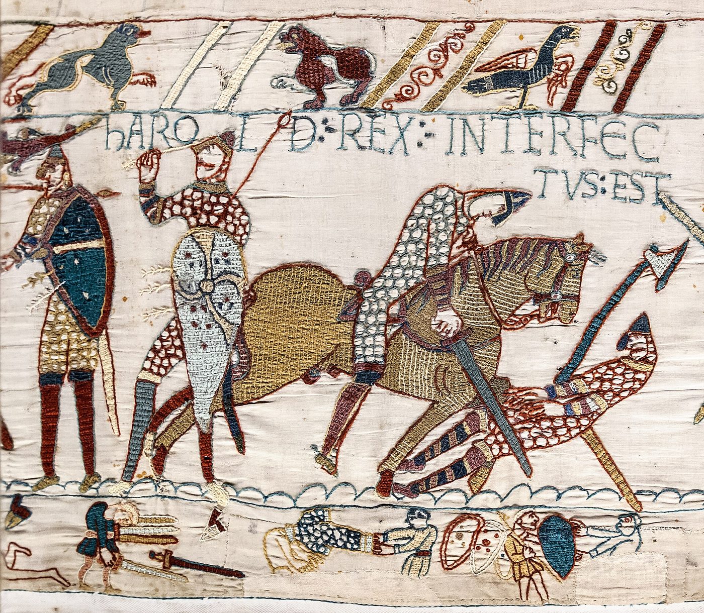
The most famous record of these events is the Bayeux Tapestry, an embroidery about seventy metres long, probably made in England in the 1070s and most likely commissioned by Odo, Bishop of Bayeux and William's half-brother. It is not a neutral chronicle. It tells the story as a question of broken faith: Harold swears an oath on holy relics, takes the crown anyway and is punished. The Channel crossing, the landing and the building of a fortification unfold like a moving map, turning the sea into a bridge and England into a destination. Nearly a thousand years later, the Tapestry still decides which images most people associate with 1066.

Bayeux Tapestry (1070s), scene 57:
Bayeux Tapestry (1070s), scene 57: "HIC HAROLD REX INTERFECTUS EST" (Here King Harold is killed).Source: Photo Myrabella, Wikimedia Commons → Licence: Public domain → file page

Primary source: verified quote

HIC HAROLD REX INTERFECTUS EST ("Here King Harold is killed").

→ Embroidered inscription, Bayeux Tapestry, scene 57 (1070s), Bayeux Museum.

Map lab: the Tapestry as a moving map

Bayeux Tapestry (1070s), scene 38: the Norman fleet crosses the Channel.
Bayeux Tapestry (1070s), scene 38: the Norman fleet crosses the Channel.Source: Wikimedia Commons → Licence: Public domain → file page
  1. Observe → Describe how the ships, the sea and the horses are arranged in this scene. Where is the viewer's eye led?
  2. Interpret → The Tapestry has no compass and no scale. In what way does it still work like a map of the conquest?
  3. Debate → "A story told in pictures can claim a territory as surely as a map." Do you agree?

Vocabulary

claimant
a person who says he or she has a right to something, here the throne
to invade
to enter a territory by force
earl
a powerful Anglo-Saxon noble governing a large region
oath
a solemn promise, often sworn on something sacred
to commission
to order and pay for a work of art
stronghold
a fortified place, such as a castle
landholder
a person who owns or controls land
bias
a one-sided view that favours one side

Analyse and debate

  • Why was the Battle of Hastings not the end of the conquest?
  • Whose point of view does the Tapestry adopt? Find two clues.
  • Why does the Tapestry still dominate the collective memory of 1066?

Sentence starters (use them!)

Every answer, oral or written, must use at least two of these starters.

The Tapestry portrays Harold as…This scene is designed to make the viewer feel…It is worth noting that the patron was…From a Norman perspective,…This raises the question of whether…

Speak

Role-play: one pupil is a Norman embroiderer, another an English monk. Each defends their version of the events of 1066 in two minutes.

Write

Write the caption for a missing scene of the Tapestry, told from an English point of view (about 120 words).

Answer key: suggested answers
  • Hastings removed Harold, but William still had to suppress revolts (for example in the north), build castles and transfer land: control of territory took years.
  • Norman viewpoint: Harold's oath and its betrayal, the heroic role of William and Odo, the patron's identity.
  • The Tapestry survives, is visually striking and is reproduced everywhere: images often outlive written chronicles in public memory.

Create and play: Stitch the Story

Each group designs a new panel of the Tapestry (drawing or collage) showing a scene the Normans left out. The class must guess what is missing and who would want it hidden. Best clue wins.

Stage 2 → 1085 → 1086

Domesday: counting a kingdom

Welcome to this stageDomesday: counting a kingdom

Welcome to the greatest survey of the medieval world. Twenty years after the conquest, William wanted to know exactly what he owned, down to the last ox and pig, and his commissioners recorded it all in Domesday Book. In this stage, you will explore a page of that astonishing document and discover that a map does not always need lines: sometimes it is a list of land, people and wealth. You will play the part of a village jury, debate the power of data, and turn into Domesday detectives.

Hook

Every app on a phone collects data about where people go and what they own. What could a ruler do with that kind of information?

Read: the text

At Christmas 1085, at Gloucester, William the Conqueror held what the Anglo-Saxon Chronicle calls a long and deep discussion with his council about England: how it was occupied and by what sort of men. The result was an inquiry without equal in medieval Europe. In 1086, royal commissioners travelled across the shires, questioning juries in every hundred about each estate: who held it in the time of King Edward, who held it now, how many ploughs, mills, meadows, woods and people it contained, and what it was worth.

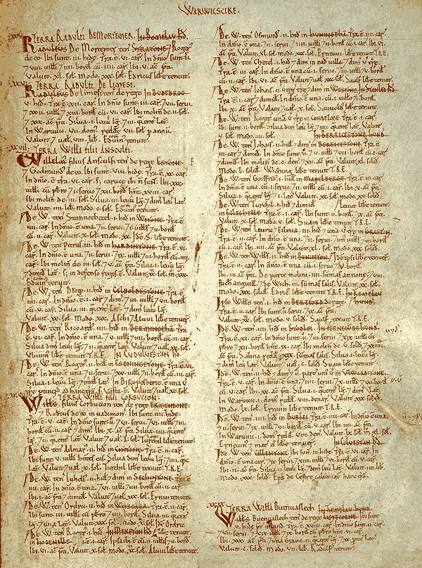
The returns were condensed into two volumes that the English soon nicknamed "Domesday", after the Day of Judgement, because, as a royal official explained around 1179, there was no appeal against its verdict. Domesday Book is not a map in the modern sense: there are no lines, no coastlines, no symbols. Yet it maps England in another way, as a grid of property and obligation laid over the entire kingdom.

That grid is the skeleton of what historians call feudal England. The king owned everything in principle; tenants-in-chief held their lands from him in return for military service; they in turn granted land to knights, while peasants, many of them unfree villeins, worked the soil. Domesday records how far the old English elite had been replaced: by 1086, only a handful of the great landholders were English. A survey can describe a territory; this one also recorded a conquest.

Primary source: verified quote

"So very narrowly he caused it to be traced out, that there was not one single hide, nor one yard of land, nay, moreover (it is shameful to tell, though it seemed to him no shame to do), not even an ox, nor a cow, nor a swine was left, that was not set down in his writ."

→ Anglo-Saxon Chronicle, entry for 1085, translated by James Ingram (1823).

Map lab: a map without lines

Domesday Book (1086), the opening of the Warwickshire entries.
Domesday Book (1086), the opening of the Warwickshire entries.Source: Wikimedia Commons → Licence: Public domain → file page
  1. Observe → Look at the page layout. What visual signs (colour, capitals, columns) help a reader find information quickly?
  2. Interpret → Imagine turning one Domesday entry into a modern map. Which layers would you need (land, people, value, owner)?
  3. Debate → Is a database of land and people a more powerful "map" than a drawing of a coastline? Why?

Vocabulary

inquiry
an official investigation
commissioner
an official sent to carry out a specific task
shire
a county, the main administrative unit of England
hundred
a subdivision of a shire
estate
a large area of land owned by one person
tenant-in-chief
a lord who held land directly from the king
villein
an unfree peasant bound to a lord
obligation
a duty one is required to perform

Analyse and debate

  • Why did the English call the survey "Domesday"?
  • In what way can a written list be considered a map of territory?
  • What tone does the Chronicle adopt about the survey? Quote a phrase.

Sentence starters (use them!)

Every answer, oral or written, must use at least two of these starters.

The survey was meant to…Strictly speaking, Domesday is not…, but…The chronicler's indignation is clear when…Knowledge of the land gave the king…Seen from below, the survey must have felt…

Speak

In groups of three, stage a Domesday hearing: a commissioner, a lord and a village jury. Ask and answer at least six questions about an imaginary estate.

Write

You are a monk in 1086. Write a 150-word chronicle entry about the commissioners arriving in your shire.

Answer key: suggested answers
  • Because its verdict was final, like the Last Judgement: there was no appeal.
  • It locates every estate in a shire and hundred, records its resources and owner: it organises space through data, not drawing.
  • Hostile and shocked: "it is shameful to tell", "not even an ox, nor a cow, nor a swine".

Create and play: Domesday Detectives

Groups invent five estate cards (owner, ploughs, mills, people, value). Another group must rebuild a map of the "shire" from the cards alone, then decide which lord is the most powerful.

Stage 3 → 1215 → 1295

Magna Carta and the birth of Parliament

Welcome to this stageMagna Carta and the birth of Parliament

Welcome to Runnymede, where a king was forced to accept that he too was bound by law. In this stage, you will read the most famous clause of Magna Carta and follow the slow birth of Parliament, from Simon de Montfort's assembly of 1265 to Edward I's Model Parliament of 1295. Alongside these milestones, you will explore one of the earliest surviving maps of Britain, drawn by the monk Matthew Paris around 1250. You will debate who should have a say when the rules are written, then draft and negotiate your own charter.

Hook

School rules, game rules, platform rules: who should have a say when the rules are written?

Read: the text

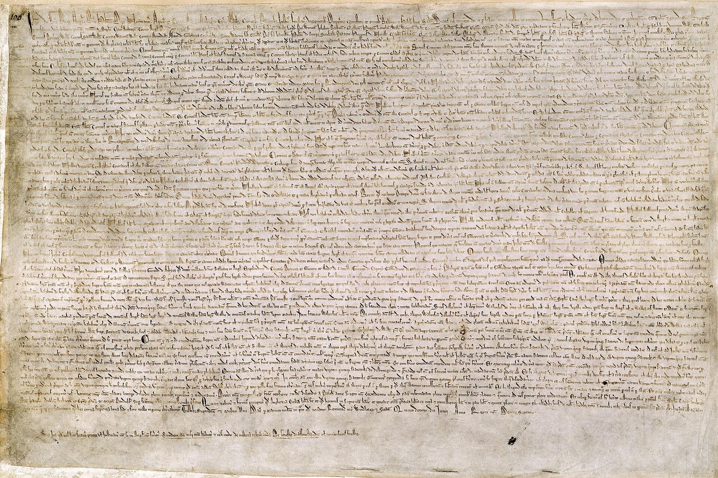
By 1215, King John had lost Normandy, imposed heavy taxes and quarrelled with the Church. A group of rebel barons seized London and forced him to negotiate. On 15 June 1215, at Runnymede on the Thames, John agreed to a charter of liberties. Within weeks, both sides broke it and the Pope annulled it, yet the charter was reissued in 1216, 1217 and 1225, and by then it had a name: Magna Carta, the Great Charter.

Most of its clauses deal with feudal grievances: inheritance, forests, fines. A few, however, stated principles that later generations would invest with enormous meaning, above all the idea that the king himself was bound by law. Clause 39 promised that no free man would be imprisoned or deprived of his rights except by the lawful judgement of his equals or by the law of the land.

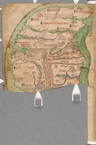
During the thirteenth century, kings needing money increasingly summoned great councils that came to be called parliaments. In January 1265, Simon de Montfort, who had defeated Henry III, called an assembly that included not only barons and bishops but also knights from the shires and burgesses from the towns. Montfort was killed at Evesham that summer, but the precedent remained. In 1295, Edward I summoned what is often called the Model Parliament. In the same decades, Matthew Paris, a monk of St Albans, drew some of the earliest surviving maps of Britain. Representation and mapping share a logic: to speak for the shires, you must first be able to name them.

Magna Carta (1215), British Library Cotton MS Augustus II.106.
Magna Carta (1215), British Library Cotton MS Augustus II.106.Source: British Library, via Wikimedia Commons → Licence: Public domain → file page

Primary source: verified quote

"No free man shall be seized or imprisoned, or stripped of his rights or possessions, or outlawed or exiled, or deprived of his standing in any other way, nor will we proceed with force against him, or send others to do so, except by the lawful judgement of his equals or by the law of the land."

→ Magna Carta (1215), clause 39, English translation published by the British Library.

Map lab: Matthew Paris, Britain c.1250

Matthew Paris, map of Britain (c.1250), Chronica Maiora part 2, Parker Library MS 16, fol. iv verso.
Matthew Paris, map of Britain (c.1250), Chronica Maiora part 2, Parker Library MS 16, fol. iv verso.Source: Parker Library, Corpus Christi College Cambridge, via Wikimedia Commons → Licence: Public domain → file page
  1. Observe → What is drawn large, and what is squeezed or missing? Look at the north and at the coasts.
  2. Interpret → Matthew Paris organised his map around a route through the kingdom. What does this tell you about how a monk experienced territory?
  3. Debate → Does an assembly representing the shires need a shared picture of the kingdom? Can a map help create a political community?

Vocabulary

baron
a powerful noble holding land from the king
charter
a formal written document granting rights
to annul
to declare officially that something is no longer valid
grievance
a complaint about unfair treatment
to summon
to order someone to come
burgess
a representative of a town
precedent
an earlier event used as an example or rule
representation
the fact of speaking or acting for a group

Analyse and debate

  • Why did Magna Carta survive even though it failed in 1215?
  • Explain the importance of the phrase "the law of the land".
  • What was new about the 1265 assembly?

Sentence starters (use them!)

Every answer, oral or written, must use at least two of these starters.

Although it failed at first, the charter…The key principle here is that…By including knights and burgesses, Montfort…This clause has been reinterpreted as…It would be anachronistic to claim that…

Speak

Debate in two teams: "Magna Carta was a deal between rich men, not a charter of freedom." Three arguments per side, one rebuttal each.

Write

Write a 180-word paragraph explaining how Magna Carta became a symbol rather than just a legal text.

Answer key: suggested answers
  • Because it was reissued (1216, 1217, 1225), confirmed by later kings and constantly cited: its memory grew larger than its original purpose.
  • It limits royal power: the king cannot act outside established law and judgement.
  • It included elected representatives of the shires (knights) and of the towns (burgesses), not only great lords.

Create and play: Charter Clash

Each group drafts three clauses for a new "charter" governing a fictional kingdom map. Groups present, negotiate and vote. A clause passes only if it uses "the law of the land" or an equivalent principle.

Stage 4 → 1348 → 1381

Black Death and the Peasants' Revolt

Welcome to this stageBlack Death and the Peasants' Revolt

Welcome to a century of catastrophe and courage. In this stage, you will see how the Black Death swept across England in 1348, how survivors began to demand a fairer share, and how anger exploded in the Peasants' Revolt of 1381. Your map is the Gough Map, the oldest surviving map to show Great Britain in a recognisable shape, crossed by the roads that carried plague, tax collectors and rebels alike. You will deliver a news bulletin from Smithfield, give voice to John Ball, and design a game where rumours race along medieval roads.

Hook

How fast can news, a rumour or a virus cross a country today? What made it slower, or faster, in the past?

Read: the text

In the summer of 1348, plague reached England through a port in Dorset. Within two years, it had killed somewhere between a third and a half of the population, according to most estimates. Whole villages shrank or vanished. The survivors faced a world turned upside down: there were fewer hands to work the land, and labourers began to demand higher wages and better conditions.

Landowners responded with force of law. The Ordinance of Labourers (1349) and the Statute of Labourers (1351) tried to freeze wages at their old level. Resentment grew for a generation. When the government, short of money for war, imposed a series of poll taxes in 1377, 1379 and 1380, the anger exploded. In June 1381, rebels from Essex and Kent marched on London, burned the Savoy Palace, entered the Tower and killed the Archbishop of Canterbury.

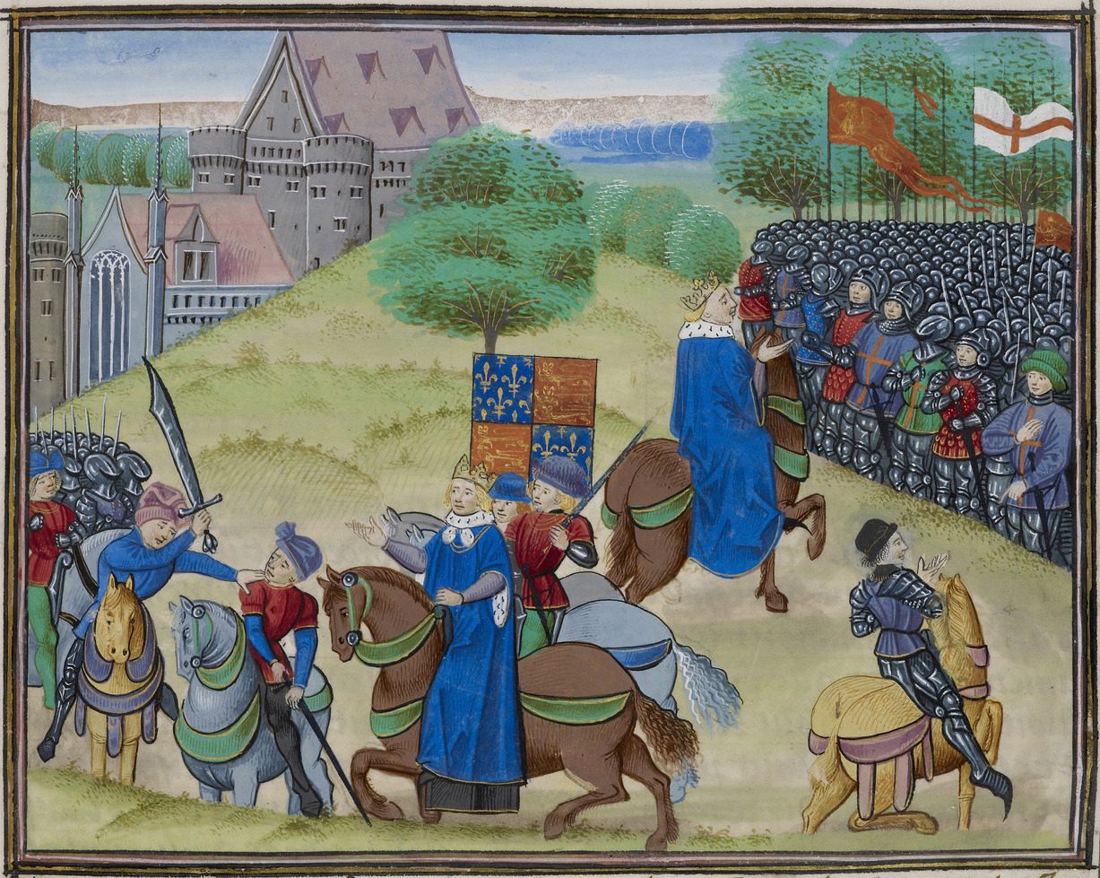
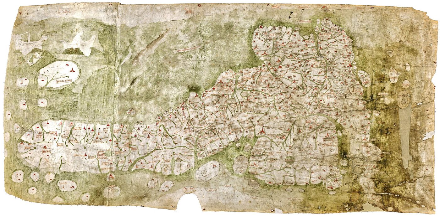
On 15 June, at Smithfield, the fourteen-year-old Richard II met the rebels. Their leader, Wat Tyler, was struck down by the Mayor of London, William Walworth, and the king promised the crowd that he would be their leader. The promises were soon withdrawn and the revolt was crushed. Around the same time, an unknown mapmaker produced the Gough Map, the oldest surviving map to show Great Britain in a recognisable shape, crossed by red lines marking routes and distances. It shows a kingdom held together by roads: the same roads that carried tax collectors, plague and rebels.

The death of Wat Tyler at Smithfield, 15 June 1381, in Jean Froissart's Chronicles (c.1475-1483), BL Royal MS 18 E I, f.175.
The death of Wat Tyler at Smithfield, 15 June 1381, in Jean Froissart's Chronicles (c.1475-1483), BL Royal MS 18 E I, f.175.Source: British Library, via Wikimedia Commons → Licence: CC0 / public domain → file page

Primary source: verified quote

"When Adam delved and Eve span, who was then the gentleman?"

→ Theme of the sermon preached by John Ball at Blackheath in June 1381, as recorded by the chronicler Thomas Walsingham.

Map lab: the Gough Map, c.1360

The Gough Map of Great Britain (c.1360, possibly updated c.1400). East is at the top.
The Gough Map of Great Britain (c.1360, possibly updated c.1400). East is at the top.Source: Bodleian Libraries / goughmap.org, via Wikimedia Commons → Licence: Public domain → file page
  1. Observe → East is at the top of this map. Turn it mentally until you recognise Great Britain. What feels strange?
  2. Interpret → The red lines show routes with distances. Who needed this kind of information: merchants, royal officials, pilgrims, rebels?
  3. Debate → Does a road network unite a territory, or make it easier to control? Can it do both?

Vocabulary

plague
a deadly infectious disease spreading rapidly
labourer
a worker doing physical work, often on the land
wage
money paid for work
statute
a law passed by the king and Parliament
poll tax
a tax of the same amount on every person
resentment
bitter anger at unfair treatment
to crush
to defeat completely by force
to delve
old verb meaning to dig

Analyse and debate

  • How did the Black Death change the balance of power between lords and labourers?
  • Why did the poll taxes act as a trigger?
  • What does John Ball's question challenge?

Sentence starters (use them!)

Every answer, oral or written, must use at least two of these starters.

The labour shortage meant that…The government's response only…The immediate trigger was…John Ball's question undermines…In the long run, the revolt…

Speak

Prepare a 2-minute news bulletin from June 1381 reporting events in London, with an "on the spot" correspondent at Smithfield.

Write

Write John Ball's sermon as a short persuasive speech (about 150 words), using the verified quote as its opening line.

Answer key: suggested answers
  • Labour became scarce, so workers could demand more; lords tried to block this by law, creating long-lasting tension.
  • They hit everyone at the same rate, after years of frozen wages: the revolt had deeper causes but the tax lit the fuse.
  • It challenges the idea that social hierarchy is natural or God-given: at creation, there were no lords.

Create and play: Rumour Routes

Groups draw a simplified road network inspired by the Gough Map and invent a board game in which a rumour, a tax collector and a rebel band race between towns. Rules must be explained in English in under one minute.

Stage 5 → 1455 → 1485

Wars of the Roses and Bosworth

Welcome to this stageWars of the Roses and Bosworth

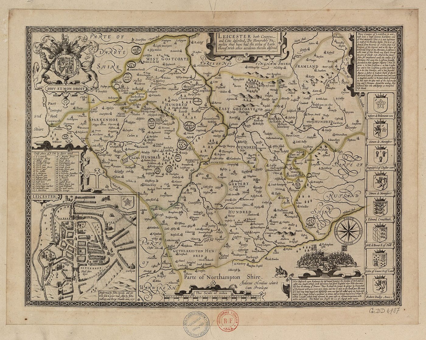
Welcome to the Wars of the Roses, a family feud that tore the crown apart for thirty years. In this stage, you will follow the rise and fall of Richard III, from the mystery of the Princes in the Tower to his death at Bosworth in 1485. You will explore John Speed's map of Leicestershire and discover how a battlefield was misplaced for centuries and a king rediscovered under a car park in 2012. Then you will put Richard on trial and decide for yourselves how he should be remembered.

Hook

Why do people still argue online about a king who died more than five hundred years ago?

Read: the text

From 1455, two branches of the royal family, Lancaster and York, fought intermittently for the crown. The conflict, later called the Wars of the Roses, grew out of the weak rule of Henry VI, rivalry between great noble houses and the loss of English lands abroad. Edward IV of York seized the throne in 1461, lost it, regained it in 1471 and ruled until his death in 1483.

His twelve-year-old son was proclaimed Edward V, but within weeks his uncle Richard, Duke of Gloucester, had declared the boy illegitimate and taken the crown as Richard III. Edward and his younger brother, the "Princes in the Tower", disappeared. On 22 August 1485, near Market Bosworth in Leicestershire, Richard faced Henry Tudor, a Lancastrian exile. The decisive intervention of the Stanley family helped Henry win. Richard was killed, and Henry VII married Elizabeth of York, uniting the two roses.

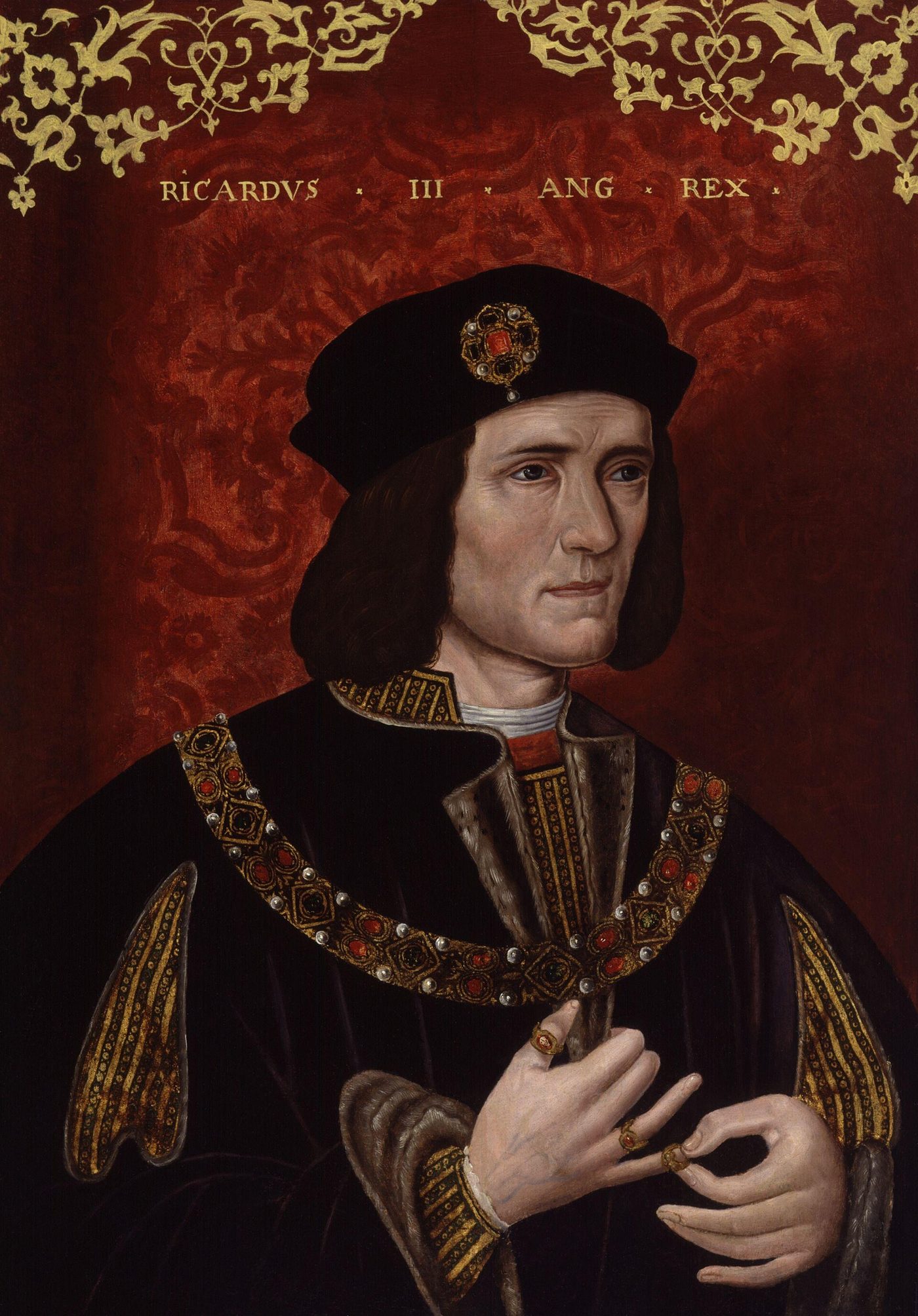
Memory then took over. Tudor writers, and later Shakespeare, portrayed Richard as a monster. Even the battlefield was misplaced for centuries: archaeologists located the most likely site only around 2009-2010, some distance from the traditional spot. In 2012, Richard's skeleton was found under a car park in Leicester, on the site of a vanished friary; in 2015 he was reburied in Leicester Cathedral. A territory can forget where its history happened, and rediscover it.

King Richard III, anonymous portrait (late 16th century).
King Richard III, anonymous portrait (late 16th century).Source: National Portrait Gallery, London, via Wikimedia Commons → Licence: Public domain → file page

Primary source: verified quote

"A horse! a horse! my kingdom for a horse!"

→ William Shakespeare, Richard III (c.1592-1593), Act 5, Scene 4.

Map lab: John Speed's Leicestershire, 1611

John Speed, Leicester both Countye and Citie described (1610-1611), engraved by Jodocus Hondius.
John Speed, Leicester both Countye and Citie described (1610-1611), engraved by Jodocus Hondius.Source: National Library of France (BnF Gallica), via Wikimedia Commons → Licence: Public domain → file page
  1. Observe → Find the city of Leicester and its inset town plan. Then look for the town of Bosworth.
  2. Interpret → Speed published this map more than a century after the battle, under the Stuarts. What might a reader of 1611 expect to learn about Leicestershire's past from it?
  3. Debate → Who should decide how a battlefield is marked and remembered: historians, local people, tourism offices, descendants?

Vocabulary

branch
a part of a family descending from one ancestor
intermittently
not continuously, with breaks
to seize
to take suddenly and by force
illegitimate
not recognised as lawful
exile
a person forced to live away from his or her country
decisive
having a very important effect on the result
to portray
to represent or describe in a particular way
friary
a religious house of friars

Analyse and debate

  • Why did Richard III's reputation become so negative?
  • Why is it significant that the battlefield was misplaced for centuries?
  • How did the discovery of 2012 change the memory of Richard III?

Sentence starters (use them!)

Every answer, oral or written, must use at least two of these starters.

Tudor propaganda had every reason to…Shakespeare's line suggests that…The rediscovery of the site shows that…Memory is shaped less by facts than by…It would be fair to say that…

Speak

Mock trial: "Richard III, did you seize the crown unlawfully?" Prosecution, defence and witnesses; the class acts as jury.

Write

Write a 170-word visitor panel for the battlefield site, presenting both the facts and the debates around Richard III.

Answer key: suggested answers
  • The Tudor dynasty owed its legitimacy to his defeat; its historians and later Shakespeare blackened his name.
  • It shows that memory and territory can drift apart: the commemorated spot was not where the fighting most likely happened.
  • It renewed public interest, led to a new burial and revived debates about his character and rule.

Create and play: Rose Rivals

Groups create a set of trump cards (York vs Lancaster) with categories such as Allies, Territory, Reputation and Luck. They then play and must justify each win with a historical sentence.

Stage 6 → 1534 → 1603

Tudors: the queen on the map

Welcome to this stageTudors: the queen on the map

Welcome to the age of the Tudors, when power was not only exercised but carefully staged. In this stage, you will see how Henry VIII broke with Rome and how Elizabeth I faced the Spanish Armada with a speech that still echoes today. You will explore Christopher Saxton's atlas of 1579 and the famous Ditchley portrait, in which the queen literally stands on a map of England. You will decode royal symbols, perform the Tilbury speech, and design a portrait of your own imaginary ruler.

Hook

Influencers carefully choose the background of their photos. What can a background say about power?

Read: the text

When the Pope refused to annul Henry VIII's marriage to Catherine of Aragon, the king broke with Rome. The Act of Supremacy of 1534 declared him supreme head of the Church of England, and between 1536 and 1540 the monasteries were dissolved, their lands sold or granted to loyal subjects. The break redrew the map of property in England more radically than anything since Domesday.

Henry's daughter Elizabeth I, queen from 1558 to 1603, inherited a divided realm. Her religious settlement of 1559 tried to hold Protestants and Catholics within one national Church. Abroad, rivalry with Catholic Spain culminated in 1588, when the Spanish Armada sailed to support an invasion. Elizabeth addressed her troops at Tilbury in August; the Armada, harried by English ships and scattered by storms, failed.

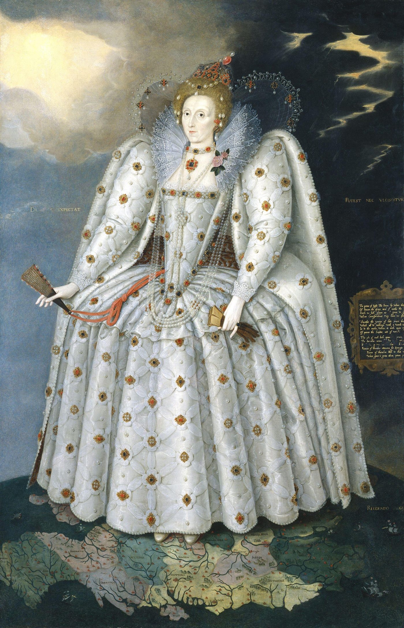
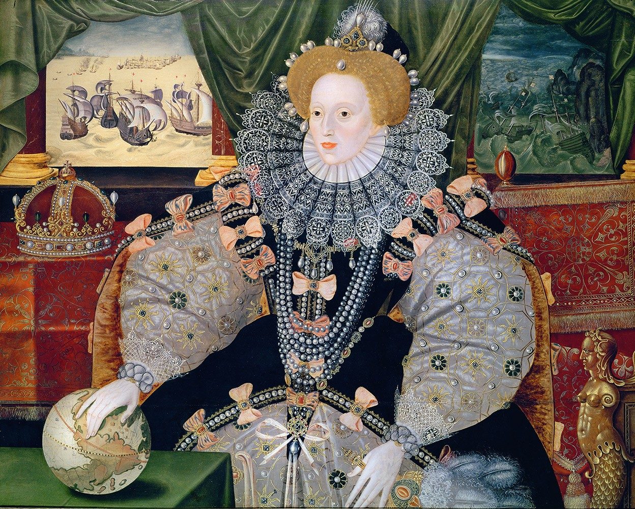
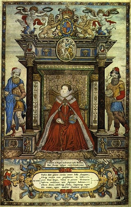
Elizabethan power was also visual and geographical. In the 1570s, Christopher Saxton surveyed every county of England and Wales with royal support; his atlas of 1579, often described as the first national atlas, put the royal arms on its maps and the queen herself on its frontispiece. Around 1592, the Ditchley portrait showed Elizabeth standing on a map of England, storms behind her and sunshine ahead. The message is unmistakable: the queen is the land, and the land is hers.

Marcus Gheeraerts the Younger, Queen Elizabeth I, the
Marcus Gheeraerts the Younger, Queen Elizabeth I, the "Ditchley portrait" (c.1592). The queen stands on a map of England.Source: National Portrait Gallery, London, via Wikimedia Commons → Licence: Public domain → file page
The Armada Portrait of Elizabeth I (c.1588), formerly attributed to George Gower.
The Armada Portrait of Elizabeth I (c.1588), formerly attributed to George Gower.Source: Wikimedia Commons → Licence: Public domain → file page

Primary source: verified quote

"I know I have the body of a weak and feeble woman; but I have the heart and stomach of a king, and of a king of England too."

→ Elizabeth I, speech to the troops at Tilbury, August 1588, as recorded by Leonel Sharp (letter first printed in Cabala, 1654).

Map lab: Saxton's atlas (1579) and the Ditchley portrait

Frontispiece of Christopher Saxton's atlas of England and Wales (1579), attributed to Remigius Hogenberg: Elizabeth I enthroned.
Frontispiece of Christopher Saxton's atlas of England and Wales (1579), attributed to Remigius Hogenberg: Elizabeth I enthroned.Source: Wikimedia Commons → Licence: Public domain → file page
  1. Observe → On the frontispiece, list the symbols surrounding the queen. In the Ditchley portrait, what exactly is under her feet?
  2. Interpret → Why would a queen want her image at the opening of an atlas, or her feet on a map?
  3. Debate → "Whoever controls the image of the land controls the land." Discuss with reference to both sources.

Vocabulary

supreme head
the highest authority
to dissolve
to close down officially
realm
a kingdom
settlement
an official agreement ending a dispute
to culminate
to reach the highest point
to harry
to attack repeatedly
frontispiece
an illustration at the start of a book
coat of arms
a set of symbols representing a family or a state

Analyse and debate

  • How did the break with Rome change the territory of England, not only its religion?
  • Analyse the rhetorical strategy of the Tilbury speech.
  • How do the Armada and Ditchley portraits use geography to express power?

Sentence starters (use them!)

Every answer, oral or written, must use at least two of these starters.

By breaking with Rome, Henry…The queen turns a weakness into…The globe under her hand suggests…Saxton's atlas served both to…and to…The portrait conveys a sense of…

Speak

In pairs, deliver an extract of the Tilbury speech, then explain in one minute three rhetorical devices it uses.

Write

Analyse the Ditchley portrait as a political map in about 200 words.

Answer key: suggested answers
  • The dissolution transferred vast monastic lands to the crown and to loyal subjects, redrawing the map of ownership.
  • Concession then reversal: she admits a "weak and feeble" body and claims the heart of a king; repetition of "king" and national pride ("of England too").
  • Armada portrait: hand on a globe, victorious fleet in the background, global ambition. Ditchley: she stands on England, mastering the storm: monarch and territory merge.

Create and play: Map the Monarch

Each group designs a symbolic portrait of an imaginary ruler standing on a map. Other groups decode every symbol. A point is scored for each symbol correctly explained in a full sentence.

Stage 7 → 1603 → 1658

Stuarts, civil war and regicide

Welcome to this stageStuarts, civil war and regicide

Welcome to the most dramatic decades in English history, when a nation went to war with its own king. In this stage, you will follow the conflict between Charles I and Parliament, from the first battles of 1642 to the trial and execution of a monarch in 1649, and the rule of Oliver Cromwell. You will explore a battle plan drawn for the Royalist army at Marston Moor and ask what happens to people when they become symbols on a map. You will interview Charles and Cromwell in the hot seat, then brief your classmates on a battle plan of your own.

Hook

Can a country put its own leader on trial? What would that do to the way people see power?

Read: the text

In 1603, James VI of Scotland became James I of England, uniting two crowns but not two kingdoms. His son Charles I believed that kings answered to God alone. He ruled without Parliament from 1629 to 1640, raised controversial taxes such as ship money and tried to impose religious changes on Scotland. War with the Scots forced him to recall Parliament, and conflict between crown and Parliament turned into civil war in 1642.

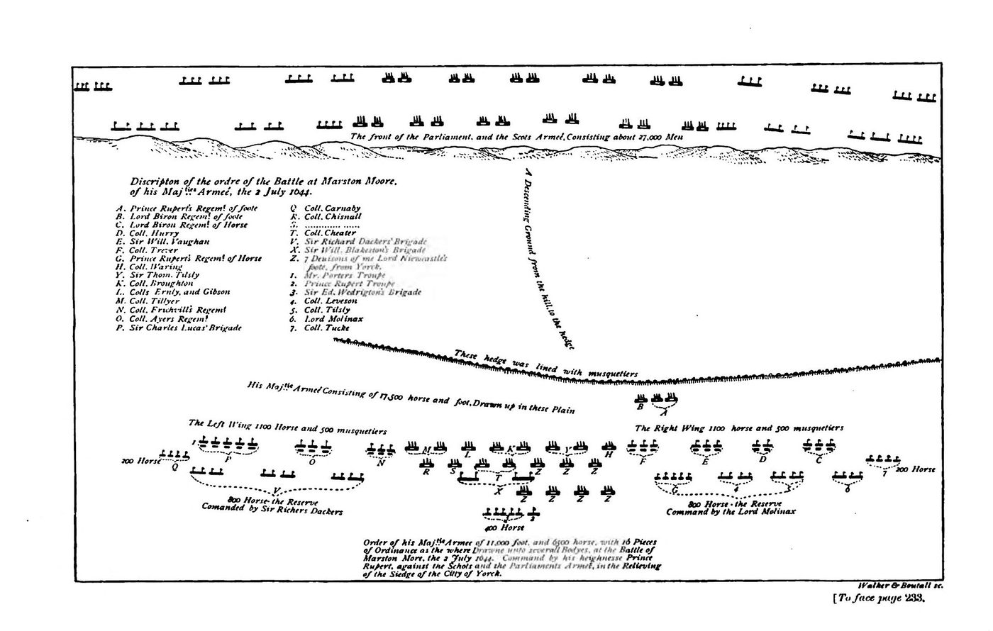
The war divided counties, towns and families. Armies needed accurate information about terrain, roads and enemy positions, and military engineers drew battle plans, such as Sir Bernard de Gomme's plan of the Royalist positions at Marston Moor in July 1644, a battle won by Parliament and its Scottish allies. After Parliament's New Model Army won at Naseby in 1645, the king's cause collapsed.

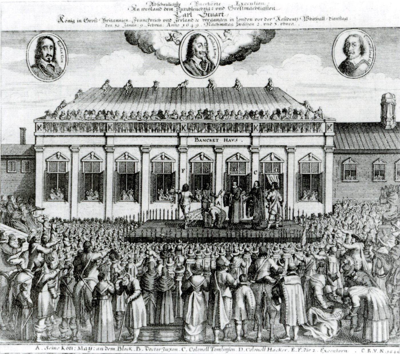
In January 1649, Charles was tried for treason against his own people, an unprecedented act. On 30 January, he was beheaded outside the Banqueting House in Whitehall. The monarchy was abolished. Oliver Cromwell's campaign in Ireland that year, including the sieges of Drogheda and Wexford, remains one of the most bitterly remembered episodes in Irish memory. Cromwell ruled as Lord Protector from 1653 until his death in 1658. Few figures in British history are remembered so differently in different parts of the islands.

The execution of Charles I outside the Banqueting House, Whitehall, 30 January 1649 (contemporary print, c.1649).
The execution of Charles I outside the Banqueting House, Whitehall, 30 January 1649 (contemporary print, c.1649).Source: Wikimedia Commons → Licence: Public domain → file page

Primary source: verified quote

"I go from a corruptible to an incorruptible Crown, where no disturbance can be, no disturbance in the World."

→ Charles I, words on the scaffold, 30 January 1649, printed in King Charls his Speech made upon the Scaffold at Whitehall-Gate (London, 1649).

Map lab: a battle plan, Marston Moor 1644

Sir Bernard de Gomme, plan of the Royalist positions at Marston Moor, 2 July 1644 (19th-century printed reproduction).
Sir Bernard de Gomme, plan of the Royalist positions at Marston Moor, 2 July 1644 (19th-century printed reproduction).Source: Wikimedia Commons → Licence: Public domain → file page
  1. Observe → What does this plan show and what does it leave out (landscape, soldiers' faces, casualties)?
  2. Interpret → Who was this plan made for, and what decisions could it help to take?
  3. Debate → A battle map turns people into symbols. Is that necessary for war, dangerous for memory, or both?

Vocabulary

to impose
to force something on people
ship money
a tax traditionally levied on coastal areas for the navy
terrain
an area of land, considered for its physical features
position
the place where troops are stationed
treason
the crime of betraying one's country or ruler
unprecedented
never done or known before
regicide
the killing of a king
Lord Protector
title of Cromwell as head of state, 1653-1658

Analyse and debate

  • Why did the conflict between Charles I and Parliament turn into war?
  • Why was the trial and execution of a king a turning point?
  • Why is Cromwell remembered so differently across the British Isles?

Sentence starters (use them!)

Every answer, oral or written, must use at least two of these starters.

Charles's conception of kingship meant that…Putting a king on trial implied that…On the scaffold, Charles presents himself as…In Irish memory, Cromwell is…This shows how memory depends on…

Speak

Hot-seat: one pupil plays Charles I, another Cromwell. The class asks questions about power, law and responsibility for five minutes.

Write

Write a 200-word report of the execution as a royalist journalist, then rewrite the first sentence as a parliamentarian.

Answer key: suggested answers
  • Charles ruled without Parliament, raised contested taxes and provoked a Scottish war; mistrust over who controlled the army made compromise impossible.
  • It established that a king could be judged for crimes against the people: sovereignty was being redefined.
  • In England he can be seen as a defender of Parliament; in Ireland, the campaign of 1649 makes him a symbol of conquest and violence.

Create and play: Battle Plan Briefing

Groups draw a simple battle plan for an imaginary encounter, with symbols and a key. They brief another group in exactly 60 seconds, who must redeploy the troops from the briefing alone.

Stage 8 → 1660 → 1689

Restoration and the Glorious Revolution

Welcome to this stageRestoration and the Glorious Revolution

Welcome to the end of our journey, an age of return, revolution and roads. In this stage, you will see the monarchy restored in 1660, then challenged again when William of Orange landed at Torbay in 1688 and Parliament secured the Bill of Rights. You will explore John Ogilby's Britannia of 1675, a road atlas that unrolled the kingdom like a scroll of measured miles. You will question whether a revolution can be called glorious when it was peaceful in one place and violent in another, and race along your own strip map to 1689.

Hook

Is a revolution still "glorious" if it was peaceful in one place and violent in another?

Read: the text

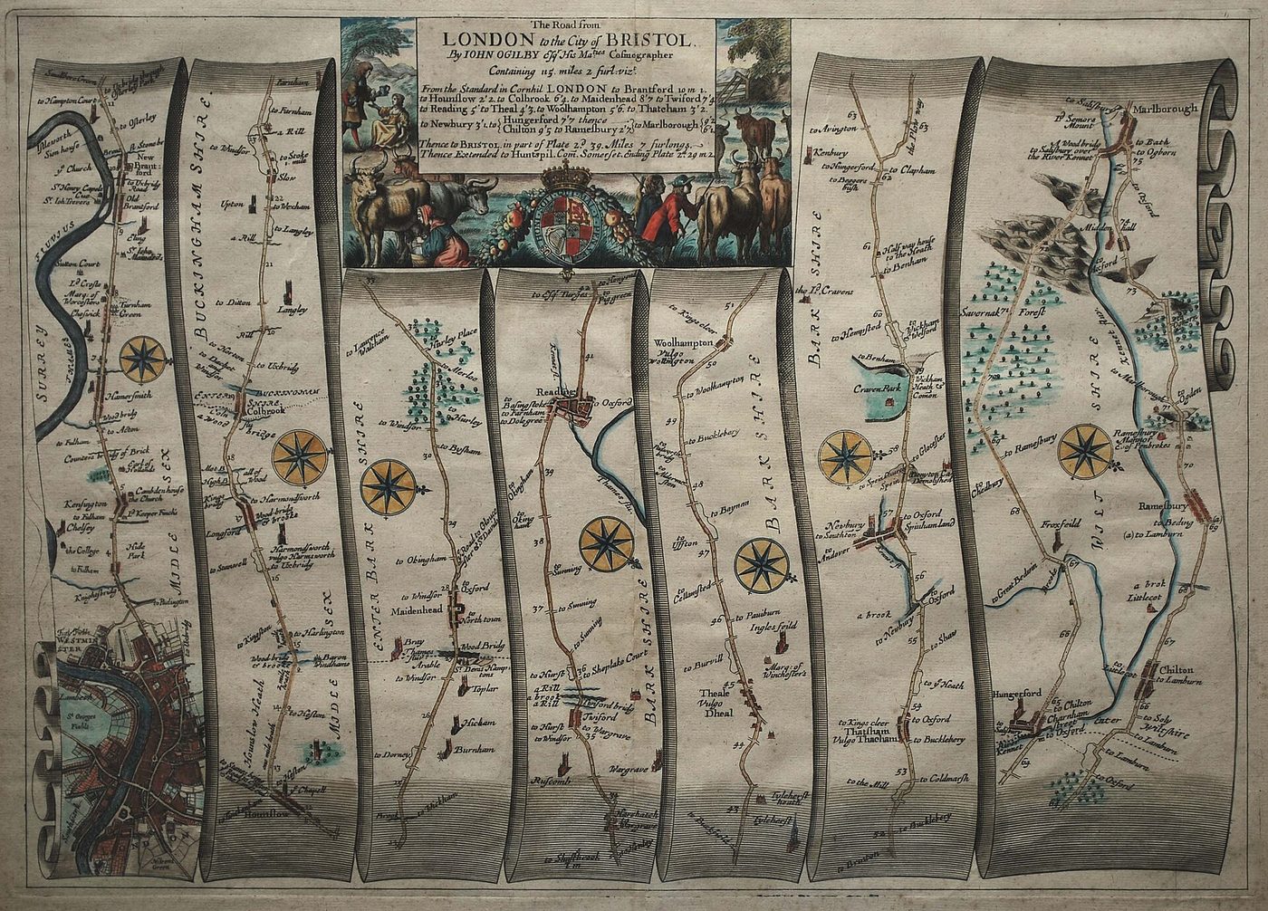
In 1660, after the collapse of the Protectorate, Charles II returned from exile: the Restoration. London survived the Great Plague of 1665 and the Great Fire of 1666, and the kingdom became more connected. In 1675, John Ogilby published Britannia, a road atlas of strip maps that unrolled each route like a scroll, measured in a standard mile of 1,760 yards. Travelling England became a matter of measured distances, not just local knowledge.

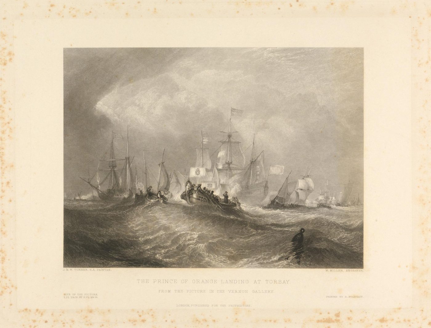
Charles's brother James II, who succeeded him in 1685, was openly Catholic and used his power to suspend laws against Catholics. When his queen gave birth to a son in June 1688, a Catholic dynasty seemed certain. A group of leading politicians invited the Dutch prince William of Orange, husband of James's Protestant daughter Mary, to intervene. William landed at Torbay on 5 November 1688; James's support melted away and he fled into exile.

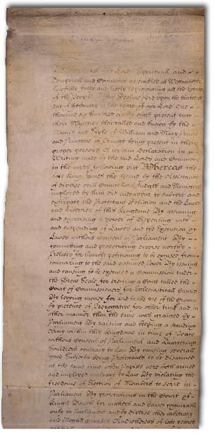
In 1689, William and Mary accepted the crown together with a Declaration of Rights, later enacted as the Bill of Rights. It declared it illegal for the crown to suspend laws or raise taxes without Parliament's consent, and it called for free elections. In England, these events became known as the "Glorious" and even "bloodless" revolution. In Ireland and Scotland, however, they led to war, including the Battle of the Boyne in 1690. A single event can sit very differently on the map of collective memory.

The Bill of Rights (December 1689).
The Bill of Rights (December 1689).Source: The National Archives (UK), via Wikimedia Commons → Licence: Public domain → file page
William Miller, The Prince of Orange Landing at Torbay (19th-century engraving recalling 5 November 1688).
William Miller, The Prince of Orange Landing at Torbay (19th-century engraving recalling 5 November 1688).Source: Yale Center for British Art, via Wikimedia Commons → Licence: CC0 / public domain → file page

Primary source: verified quote

"That the pretended power of suspending of laws or the execution of laws by regal authority without consent of Parliament is illegal." → "That election of members of Parliament ought to be free."

→ Bill of Rights 1689, articles 1 and 8 (spelling modernised; original text on legislation.gov.uk).

Map lab: Ogilby's Britannia, 1675

John Ogilby, Britannia (1675): The Road from London to the City of Bristol, a strip map.
John Ogilby, Britannia (1675): The Road from London to the City of Bristol, a strip map.Source: Wikimedia Commons → Licence: Public domain → file page
  1. Observe → Follow the road from London to Bristol. What information is recorded along the way (hills, bridges, towns, distances)?
  2. Interpret → Why would a standard mile and a national road atlas matter to a state, to merchants and to the postal service?
  3. Debate → Does connecting a territory make it more united, or more controlled? Compare with the Gough Map.

Vocabulary

restoration
the return of a former ruler or system
strip map
a map showing a single route as a long band
to succeed
to come after someone in a position
to suspend
to stop something temporarily
dynasty
a series of rulers from the same family
to intervene
to become involved to change a situation
consent
permission or agreement
to enact
to make into law

Analyse and debate

  • What did the Bill of Rights change in the relationship between crown and Parliament?
  • Why is the label "Glorious Revolution" contested?
  • How does Ogilby's atlas reflect a changing idea of the kingdom?

Sentence starters (use them!)

Every answer, oral or written, must use at least two of these starters.

From then on, the crown could no longer…The adjective "glorious" reflects…Seen from Ireland, however,…Ogilby's strip maps make the kingdom look…Ultimately, the events of 1688-1689…

Speak

Press conference, December 1689: William, a member of Parliament and a journalist from Dublin answer and ask questions about the new settlement.

Write

Write a 200-word argument: "1688 was the real birth of parliamentary government in England." Agree or disagree.

Answer key: suggested answers
  • Parliament's consent became necessary to suspend laws and to raise taxes; regular, free elections were affirmed: power shifted towards Parliament.
  • "Glorious" and "bloodless" describe England only; in Ireland and Scotland, the revolution meant war and lasting division.
  • It presents the kingdom as a measured, connected network of roads leading from London, useful to trade and to government.

Create and play: Road to 1689

Groups design a strip-map race game from 1660 to 1689: each "town" on the road is an event. Players advance by answering questions written by another group, in full sentences only.

Final project → 1066 → 1688

Final project: a memory atlas of England

Welcome to this stageFinal project: a memory atlas of England

Welcome to the final project, where you become the mapmakers. After eight stages of reading, debating and decoding maps, it is your turn to decide what deserves a place on the map of memory, and what lies in the margins. With your group, you will design a memory atlas of England from 1066 to 1688, write a curator's statement and lead your audience on a guided tour. Be bold, be precise and be ready to defend every choice, because every map tells a story, and this one will be yours.

Hook

If you had to design the map that future generations will use to remember this period, what would you put on it, and what would you dare to leave off?

Your mission

  1. In groups of three or four, create a memory atlas of England 1066-1688: one map (drawn, collaged or digital, using any tool your school provides, or simply paper) with eight numbered sites, one for each stage of the course.
  2. For each site, write a short entry (60 to 80 words): what happened there, which source or map from the course records it, and how it is remembered today. At least three entries must show a contested memory.
  3. Write a curator's statement (250 to 300 words) explaining your choices: what is at the centre of your map, what is in the margins, and why.
  4. Present your atlas as a five-minute guided tour. Every member speaks. End with one question for the audience about maps, power and memory.

Maps you can use

Sentence starters (use them!)

Your curator's statement and your tour must use at least four of these starters.

At the heart of our atlas lies…We deliberately chose to place…This site remains contested because…By leaving…in the margins, we wanted to…Our map invites the viewer to question…To sum up, our atlas argues that…

Assessment grid (4 points each, 20 in total)

Historical accuracy
Facts, dates and sources are correct and precisely used.
Map thinking
The atlas shows clearly how maps express power, memory and identity.
Language C1+
Rich, precise vocabulary; complex sentences; nuance and concession.
Oral delivery
Fluent, engaging tour; eye contact; every member speaks.
Creativity
Original design choices, justified in the curator's statement.
Answer key: what a strong project looks like
  • A successful atlas does not simply list events: it makes visible a point of view and explains it.
  • Strong examples of contested memory: 1066 (Norman vs English versions), Bosworth (misplaced battlefield, Richard's reputation), 1649 (Cromwell in England vs Ireland), 1688 ("glorious" in England, war in Ireland and Scotland).
  • A model curator's statement opens with a thesis ("Our atlas argues that…"), justifies two or three design choices and ends with a reflection on what every map leaves out.

Create and play: Atlas Gallery Walk

Atlases are displayed around the room. Visitors leave one question and one compliment on each, in English. Each group then answers the best question in front of the class.